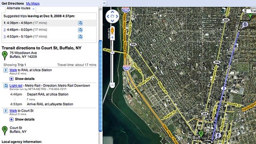
I just learned that our very own NFTA has mashed-up with google! It's so easy to use. When you've located your spot on google maps simply do the 'from here' routine and select 'public transportation' as your way to go. I generated the following map, and travel times for a meeting.
I haven't quite given up on the car, thinking about it all the time. One of the reasons why I located a block from Main Street was to take advantage of the City's subway. Two years ago I rode around the City the bus/subway on a month pass. It's still the preferred way for meet-ups and events along the City's spine from downtown to UB. Great deal for $66/month. The alternative right now might be some Suomi snows for my bike.
Like to know if anyone else is using this NFTA/google mash-up for getting around town. Very cool.Artspace • BAVPA • Woodlawn Row Houses • fixBuffalo flickr
Creative Class • Shrinking Cities • Saturdays in the neighborhood
2 comments:
More people need to think more pragmatic like you, David! The subway and mass transit would get used a lot more if more people lived on BOTH sides of Main Street.
I like the Google option for ease of use definitely, but I haven't been able to figure out how to use it to plan trips in the future instead of at the moment.
Seeing it on the map is helpful though.
Post a Comment